River Jordan: geography, history, meaning, and travel
River Jordan: geography, history, meaning, and travel
If you picture the River Jordan as a wide, rushing river, you may be surprised by parts of it today. Much of the lower river is relatively narrow, slow-moving, and affected by water diversions, but its significance remains immense. The river connects the mountains north of the Sea of Galilee with the Dead Sea and carries religious, historical, environmental, and political meaning far beyond its physical size.
The River Jordan flows generally from north to south through the Levant. It begins in the area around the Lebanon-Syria-Israel border region, passes through the Sea of Galilee, continues along or near the boundary between Israel and Jordan, and ends at the Dead Sea. Its biblical associations include the ministry of John the Baptist, the baptism of Jesus in Christian tradition, and the Israelites’ crossing into the Promised Land in the Hebrew Bible.
The river’s upper system is fed by several headwaters descending from the slopes of Mount Hermon. The main sources commonly identified are the Hasbani, which rises in Lebanon; the Banias, associated with the Golan Heights; and the Dan, which emerges from a spring near northern Israel. These streams join in the Hula Valley, creating the main channel of the River Jordan.
From the Hula Valley, the river flows south into the Sea of Galilee, also called Lake Tiberias or Lake Kinneret. This freshwater lake is the river’s largest natural body of water and a major water source for the region. After leaving the lake near its southern end, the Jordan continues through the lower valley toward the Dead Sea.
The river’s lower course forms much of the boundary between Jordan to the east and Israel and the West Bank to the west. The exact political and geographic description can vary by location, especially in areas where the river channel and administrative boundaries do not align neatly. It does not serve as the border between Jordan and Israel along its entire length.
The River Jordan has no outlet beyond the Dead Sea. Water entering the lake evaporates in the hot, dry climate, leaving behind an exceptionally high concentration of salts and minerals. This makes the Jordan part of a closed drainage system, rather than a river that eventually reaches the Mediterranean Sea or another ocean.
Geographic shortcut: Think of the River Jordan as a north-to-south water system linking Mount Hermon, the Hula Valley, the Sea of Galilee, the lower Jordan Valley, and the Dead Sea.
What the River Jordan looks like today
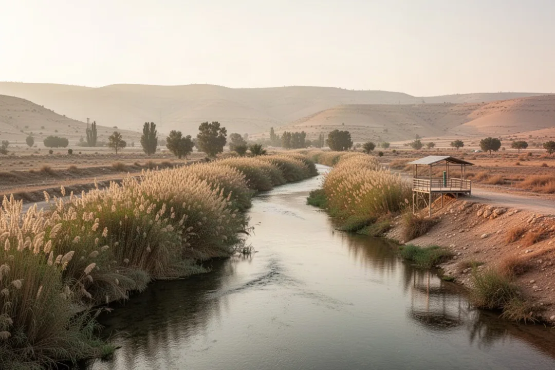
The River Jordan is not the same throughout its course. The upper river near its springs can be clear, cool, and relatively lively, with wetlands, streams, and vegetation. Around the Sea of Galilee, the landscape is more open and developed, while the lower Jordan Valley is hotter, drier, and strongly shaped by agriculture, dams, pumping stations, and irrigation channels.
The river once carried substantially more water into the Dead Sea than it does now. During the twentieth century, Israel, Jordan, Syria, and other regional users developed water infrastructure that redirected much of the river’s flow and that of its tributaries. Municipal demand, farming, drought, and climate pressures have added to the strain.
As a result, the lower Jordan River has experienced reduced flow and declining ecological health. Some sections contain treated wastewater, agricultural runoff, or high concentrations of salts and pollutants. Environmental groups and governmental agencies have worked on restoration, water-quality improvement, wetland protection, and cross-border cooperation, but the river remains under significant pressure.
The lower flow also contributes indirectly to the falling level of the Dead Sea. The Dead Sea has lost a substantial amount of surface area over the modern period, and its receding shoreline has created hazards such as sinkholes in some locations. The river is not the only cause: mineral extraction, evaporation, and regional water use also play major roles.
Why the River Jordan matters in the Bible
The River Jordan appears repeatedly in the Hebrew Bible and the New Testament. Its meaning is connected with crossing, transition, cleansing, judgment, and new beginnings. Those themes help explain why the river remains central to Jewish and Christian religious imagination even for people who have never visited it.
In the Book of Joshua, the Israelites cross the Jordan to enter the land described as the Promised Land. The account presents the crossing as a major turning point after the wilderness period. The river therefore represents movement from a long period of uncertainty toward settlement and a new stage in the community’s story.
The Jordan is also associated with the prophet Elijah and his successor Elisha. Biblical narratives place important encounters and crossings near the river, reinforcing its role as a boundary between one phase of life and another. In the stories of Elijah, the river is part of a landscape marked by prophetic authority and divine action.
John the Baptist preached and baptized in the Jordan region. The Gospels describe Jesus coming to John for baptism, an event that Christians understand as a significant beginning of Jesus’ public ministry. The New Testament does not make every detail of the setting identical to a single modern tourist site, so visitors should distinguish between biblical geography, later tradition, and present-day claims about exact locations.
The river’s symbolism is not limited to baptism. Water in biblical traditions can signify purification, repentance, danger, life, and divine provision. Because the Jordan is both a real geographic feature and a recurring religious image, references to it often carry several meanings at once.
Where Jesus was baptized according to Christian tradition
Christian tradition generally connects Jesus’ baptism with the lower Jordan Valley, in the area historically known as Bethany beyond the Jordan. The site often called Al-Maghtas, on the eastern bank in Jordan, is recognized by many Christians as the traditional location. A related baptismal area on the western bank, commonly called Qasr al-Yahud, is also visited and associated with the event.
The exact historical location cannot be established with complete certainty. The river has shifted over time, and the biblical descriptions are interpreted in different ways. Political borders, archaeological evidence, religious tradition, and access restrictions have all influenced how the sites are identified and presented.
Visitors may find that the modern river at a baptismal site is narrower and less dramatic than expected. Some locations provide steps, platforms, changing facilities, chapels, shaded areas, and places for group ceremonies. Others are quieter and more basic. The experience depends heavily on which bank and access point you visit.
People of many backgrounds visit these locations for prayer, pilgrimage, study, cultural interest, or simple curiosity. If you attend a ceremony, follow the site’s rules about entering the water, photography, clothing, and group activities. Respect for worshippers matters, especially at busy baptismal locations.
How the River Jordan shaped the region’s history
The Jordan Valley has long been a corridor between higher lands east and west of the river. Its water, fertile stretches, springs, and routes through the surrounding terrain supported settlements and agriculture. The valley also offered a recognizable natural boundary, although crossing it was possible at many points and the river did not isolate communities completely.
Ancient settlements developed near dependable water sources, particularly around the Sea of Galilee and the upper Jordan. The area was connected with important towns, trade routes, religious centers, and political powers. The Jordan Valley’s position made it strategically valuable, while its hot climate and steep surrounding slopes created practical challenges for travel and farming.
During the Roman and Byzantine periods, the region contained roads, agricultural communities, religious sites, and settlements connected to the wider eastern Mediterranean. Christian pilgrimage increased as travelers sought places associated with the life of Jesus and biblical events. Monasteries and churches were established in parts of the Jordan Valley and surrounding wilderness.
In the modern era, the river became part of a complicated political landscape. The creation of national borders, military tensions, water development, and the Israeli-Palestinian conflict affected access and river management. The Israel-Jordan peace treaty of 1994 created a framework for cooperation over water and other issues, although broader regional disputes and environmental challenges remain.
The river is therefore more than a line on a map. It is a shared water system crossing a region where environmental decisions are closely tied to agriculture, public health, economics, religion, and security.
Wildlife and ecosystems along the Jordan River
The Jordan River and its associated wetlands support habitats for fish, birds, reptiles, amphibians, and mammals. The upper river and Hula Valley are especially significant for wetland ecology and migratory birds. The valley lies along a major route used by birds moving between Europe, Asia, and Africa.
Historically, wetlands in the upper Jordan basin covered a larger area than they do today. Drainage and development changed the landscape, although some wetland areas have been restored or protected. Native plants, reeds, riparian trees, and shallow-water habitats can help stabilize banks and provide shelter for wildlife.
Reduced flow creates several ecological problems. It raises water temperatures, concentrates pollutants, interrupts fish movement, reduces habitat, and allows invasive species to spread. It can also damage the natural flood cycles that replenish wetlands and riverbank environments.
Restoration efforts usually focus on more than simply putting water back into the channel. A healthy river needs adequate environmental flow, improved wastewater treatment, protected wetlands, careful agricultural practices, and cooperation among the governments and communities that share the basin. Small changes at one location may not solve problems caused elsewhere upstream.
Practical tips for visiting the River Jordan
There is no single River Jordan visitor experience. A spring near the upper river, a lakeside location by the Sea of Galilee, a baptismal site in the lower valley, and a viewpoint near the Dead Sea can look and feel entirely different. Choose the site based on your purpose rather than assuming every location offers the same access or scenery.
Choose the correct bank and site. Jordanian and western-bank baptismal locations have different opening procedures, facilities, transportation arrangements, and border requirements.
Check current access information. Security conditions, religious ceremonies, weather, road closures, and administrative rules can change. Confirm details with official local sources before setting out.
Wear suitable clothing. Modest clothing is appropriate at religious sites. Bring a hat, sunscreen, sturdy shoes, and extra water, particularly in the lower valley.
Do not assume the water is safe. Water quality varies, and a river that looks calm may still contain contaminants, strong currents, unstable banks, or submerged hazards.
Use designated paths and platforms. Riverbanks can be muddy, steep, slippery, or fragile. Keep away from fenced areas, military zones, and unmarked crossings.
Protect the surroundings. Carry out trash, avoid disturbing birds and plants, and do not remove stones, archaeological material, or religious objects.
Allow time for heat and transport. The lower Jordan Valley can be intensely hot, and some sites require organized transport or a short walk from the entrance.
If you want to enter the water for a baptism or symbolic ritual, ask the staff where this is permitted. Many sites have designated sections and specific procedures. Do not cross the river independently, even where the channel appears narrow.
Safety warning: The River Jordan can run beside restricted or politically sensitive areas. Never treat a narrow channel as an informal crossing, and follow posted instructions from local authorities and site personnel.
Common mistakes people make about the River Jordan
Several assumptions can make a visit or research project confusing. The river’s strong symbolic reputation sometimes leads people to picture a landscape that does not match its current physical condition. A more accurate understanding separates the river’s religious importance from its modern appearance and environmental state.
Assuming it is a large, deep river everywhere: many sections are narrow and shallow, especially compared with major rivers in North America, Africa, or Europe.
Confusing the Sea of Galilee with the Dead Sea: the Jordan flows through the freshwater Sea of Galilee before reaching the much saltier Dead Sea.
Calling every baptismal site the exact biblical location: several sites are rooted in longstanding tradition, but the precise historical setting remains debated.
Believing the river itself is the only cause of the Dead Sea’s decline: diversions, evaporation, mineral extraction, agriculture, and changing water use all contribute.
Assuming the river is always suitable for swimming: access and water quality differ by location, and religious sites may prohibit ordinary swimming.
Ignoring the political geography: the river passes through and beside areas with different authorities, entry rules, and security conditions.
Expecting every site to be open year-round: schedules may vary by season, holidays, weather, religious events, and local restrictions.
How water use affects the River Jordan
Water management is the central modern challenge facing the river. Communities throughout the basin depend on water for drinking, farming, industry, energy, and ecosystems. Because the Jordan is shared across borders, one country’s diversion or release can affect people and habitats downstream.
Several tributaries and water sources feed the wider basin, including the Yarmouk River, which joins the Jordan south of the Sea of Galilee. Dams and reservoirs in the region regulate water for human use, but they also change seasonal flow patterns and reduce the amount of water reaching downstream habitats.
Wastewater treatment can improve conditions, yet treated water is not identical to a natural river flow. Salts, nutrients, pharmaceuticals, and other substances may remain, depending on the treatment system. Agricultural runoff can add fertilizers and pesticides, contributing to algal growth and harming aquatic life.
Possible solutions include increasing water efficiency, reusing treated wastewater, improving irrigation, protecting springs and wetlands, restoring natural vegetation, and agreeing on cross-border environmental flows. Desalination and water recycling may reduce pressure on freshwater sources, but they require infrastructure, energy, investment, and long-term management.
Local restoration projects can produce visible improvements, but lasting recovery depends on basin-wide planning. A restored riverbank cannot remain healthy if upstream diversions leave the channel dry or if pollution enters farther north.
How to understand the River Jordan on a map
Start at the northern headwaters and follow the river south. The first major landscape is the Hula Valley, a low-lying basin historically known for wetlands. The river then reaches the Sea of Galilee, which acts as both a major lake and an important part of the regional water system.
Below the Sea of Galilee, the Jordan enters the lower valley. The river meanders through a hot, arid landscape, with agricultural areas and smaller tributaries along the way. The Jordan Valley is bordered by higher terrain on both sides, including the hills and plateaus east and west of the river.
Finally, the river reaches the Dead Sea, whose shoreline lies far below sea level. The Dead Sea is not a conventional freshwater lake and does not drain onward. Its unusual elevation, extreme salinity, mineral-rich waters, and surrounding desert make it one of the most distinctive endpoints of any major religiously significant river.
Maps may label the river differently depending on scale and political perspective. Look for terms such as Upper Jordan, Lower Jordan, Sea of Galilee, Dead Sea, and Jordan Valley to understand which part of the system you are viewing.
Why the River Jordan remains significant
The River Jordan remains important because several kinds of meaning meet in one relatively small waterway. It is a physical river, a source of water, a habitat, a political boundary, a pilgrimage destination, and a recurring symbol in Jewish and Christian traditions.
Its present condition also raises practical questions about shared resources. The river shows how religiously important landscapes can face ordinary pressures from irrigation, cities, pollution, drought, and climate change. Protecting the Jordan requires both respect for its cultural history and careful attention to its ecological needs.
For a traveler, the best approach is to see the river in context. Visit the springs or upper valley if you want to understand its natural origins, the Sea of Galilee to see its central freshwater lake, and an authorized lower-river site to explore its baptismal traditions. Each setting reveals a different part of the same river system.
For a reader studying its history or religion, remember that the River Jordan is not only a backdrop to ancient stories. It is a living and contested waterway whose modern future depends on cooperation among the communities and countries that share it.
Frequently asked questions
Is the River Jordan in Israel or Jordan?
It is associated with both countries. The river rises in the northern Levant, flows through the Sea of Galilee, and then runs along or near the boundary between Jordan and Israel and the West Bank. Different sections are administered by different authorities, so the country you visit depends on the specific river site.
Can you swim in the River Jordan?
Swimming is not generally appropriate or permitted at every location. Water quality, currents, restricted zones, religious customs, and local rules vary. Some baptismal sites allow supervised entry in designated areas, while other sections should not be entered. Check the site’s current instructions and never cross the river.
How long is the River Jordan?
Published measurements vary because sources use different starting points and methods for tracing the river’s winding headwaters. It is commonly described as a little over 200 miles long, or roughly 300 kilometers, from its northern source system to the Dead Sea.
Why is the River Jordan so important to Christians?
Christian importance comes mainly from the New Testament accounts of John the Baptist baptizing in the Jordan region and Jesus receiving baptism there. The river also represents repentance, cleansing, and the beginning of a new spiritual life, making it a major destination for Christian pilgrims.





Leave a Reply